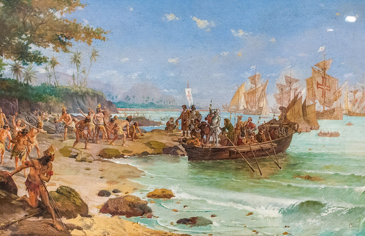
On 22 April 1500, Pedro Álvares Cabral’s fleet sighted a mountain on the coast of what is now the Brazilian state of Bahia. They called it Monte Pascoal — Easter Mountain — because Easter had been the week before. What they were looking at, legally speaking, was already Portuguese.
The Treaty of Tordesillas had been signed six years earlier, in June 1494, between Portugal and the Crown of Castile. It drew a meridian through the Atlantic Ocean, 370 leagues west of the Cape Verde Islands. East of the line belonged to Portugal. West belonged to Castile. The rest of Europe was not consulted. The rest of the world was not informed. The native populations of those lands were totaly oblivious.
The number matters. In 1493, the year before, Pope Alexander VI — a Borgia, Spanish by birth, not noticeably impartial — had drawn an earlier line 100 leagues west of Cape Verde. That version would have placed all of the New World on the Spanish side and left Portugal with nothing west of Africa. King John II of Portugal refused to accept it. He negotiated directly with Ferdinand and Isabella over the following year and pushed the line 270 leagues further west. That is the shift that matters. It is the reason Brazil exists as a separate linguistic and political entity today.
Why 370 leagues in particular? The stated reason was navigational: Portuguese captains rounding the South Atlantic needed sea room to swing west and catch favourable winds on the way to India. The suspected reason is less innocent. A number of historians have argued that Portuguese sailors already knew, or strongly suspected, that land lay in the South Atlantic within the disputed zone — possibly from a secret voyage, possibly from storm-blown reconnaissance, possibly from the commercial intelligence that Lisbon had been accumulating for decades. There is no surviving log, no archived report, no definitive evidence. But the geography is suggestive. The 370-league line cuts through what is now Pará in the north and runs down past the mouth of the Río de la Plata in the south. If you did not already suspect land was out there, you would not bother fighting for 270 additional leagues of open ocean.
Whatever John II knew, his successor Manuel I dispatched Cabral in March 1500 with thirteen ships and instructions to retrace Vasco da Gama’s route to India. Cabral swung wide into the Atlantic — the standard manoeuvre by then — and on 22 April made landfall on what he promptly named Terra de Vera Cruz, the Land of the True Cross. The expedition stayed nine days, planted a cross, traded trinkets with the Tupiniquim, sent one ship back to Lisbon with the news, and continued east to India. Brazil entered the record as a footnote in an itinerary that was really about pepper.
Portugal then spent the next thirty years largely ignoring the place it had just acquired. The Estado da Índia — the network running from Goa to Malacca to Macau — was where the profits were. Brazil had no gold, no spices, no kingdoms large enough to shake down for tribute. What it had was a dye-wood called pau-brasil, which gave the country its eventual name, and that was not enough to justify settlement. The Portuguese set up a handful of coastal trading posts, left them mostly to foreign adventurers and convicted criminals, and waited to see if anything more lucrative turned up.
Real colonisation began around 1530, when John III — alarmed that French ships were felling Brazilwood along the very coast his grandfather had secured on paper — dispatched Martim Afonso de Sousa with a proper settling expedition. Hereditary captaincies were instituted along the coast. Sugar mills went up in Pernambuco and Bahia. The Atlantic slave trade began supplying labour from West Africa on an industrial scale. Brazil stopped being a treaty reference and became a colony.
The other European powers never accepted the Treaty of Tordesillas as binding. It was a bilateral agreement between two Iberian Catholic kingdoms, mediated by a Borgia pope, and Protestant and Catholic rivals alike took the view that the Atlantic was not the Pope’s to carve up. France founded France Antarctique in the bay of Rio de Janeiro in 1555 and held it for twelve years before Mem de Sá drove them out in 1567. The Dutch took Recife in 1630 and ran a parallel Brazilian colony under the West India Company for twenty-four years before being expelled in 1654. The English contributed pirates. Portugal spent two centuries defending a line that only Spain had ever agreed to.
The people who pushed hardest against the line, though, were the Portuguese themselves. The bandeirantes — slave-hunting, gold-prospecting, flag-bearing expeditions out of São Paulo — crossed the Tordesillas meridian and kept going. They walked across half a continent over the course of the 17th century, hunting indigenous slaves, prospecting for silver, and founding mission stations hundreds of miles inside what was, on paper, Spanish territory. By the time Spain and Portugal renegotiated in the Treaty of Madrid of 1750, the principle adopted was uti possidetis — whoever is already there, keeps it. Spain lost an empire’s worth of Amazon basin because Portuguese slavers had already walked across it. The line drawn in 1494 had been quietly overtaken by facts on the ground.
The cultural consequence of the 1494 number is that the largest country in South America speaks Portuguese. Every other republic on the continent speaks Spanish, because they fell west of where the line was drawn. Change the treaty by a few degrees of longitude and Cabral in 1500 would have made landfall on Castilian territory, and the border between Spanish and Portuguese America would have been the Atlantic itself. Two hundred and ten million people speak Portuguese at home today largely because Ferdinand and Isabella agreed to a particular figure in a negotiation about ocean no one present had ever seen.
Cabral’s landing is usually told as a discovery. It was not. The territory had been assigned six years earlier by a line on a map whose signatories could not locate it with any accuracy and whose authority most of the world refused to recognise. What Cabral did on 22 April 1500 was arrive to take possession of something his king had already filed the paperwork on. The ceremony on the beach at Monte Pascoal was less a discovery than an inspection.
Which is worth remembering the next time a border looks permanent on a map. Plenty of them were drawn, at some point, by people who had not yet seen what they were dividing.